You must wear your race number and it must be clearly visible at all times. The Superior “Fall” Trail Races host three races simultaneously, the Superior 100 Mile, the Superior 50 and the Superior / Moose Mountain Marathon.  Each distance will have its own unique race number (unique color and number series) so runners can be easily identified by race officials, volunteers, spectators and other runners.  We ask that all competitors wear their number on the front of their body on their outer-most layer at all times and do not “fold down” your number.  Runners will be tracked coming into and out of each aid station.  If we cannot see your number, we cannot track you or take your finishing time and if we cannot do that, you will be disqualified and will not earn an official finish.  Additionally, 100 mile runners will be issued a piece of pink and 50 mile runners a piece of blue ribbon to be tied onto the back of your hydration pack, waist belt etc. so you can be easily identified from behind has well.

(Superior and all RSR events): We will no longer be printing your emergency contact info on the front of your bib (the only info in addition to your name will be your shirt size) – we encourage you to write-in your your emergency contact information on the back of your bib (scroll to the end of the page for the bib-back example), We will have Sharpie markers at check-in so you can do this.

We are requiring pacer bibs for 100 mile runner’s pacer(s), you will find two (2) pacer bibs in your race bag – for those that do not have pacers, you can turn those bibs back into us or share with fellow runners who may need an extra.


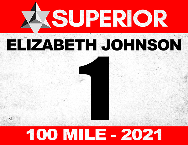
100 Mile | Color: Red | Number Series 1 – 299


Superior 100 PACER Bibs


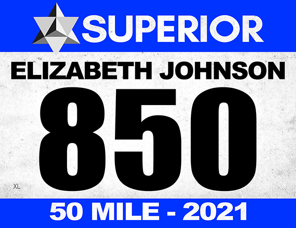
50 Mile | Color: Blue | Number Series 850 – 999


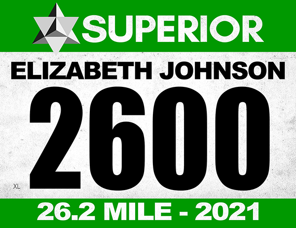
Marathon | Color: Green | Number Series 2600+


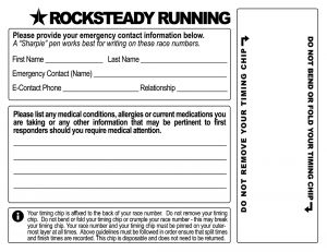
Chip Timing / Back of Bib

+


The Superior ‘Fall’ Trail Race 100, 50 and 26.2MI will be chip timed. Your timing chip will be affixed to the back of your race number. Do not remove your timing chip. Do not bend or fold your timing chip or crumple your race number – this may break your timing chip. Your race number and your timing chip must be pinned on your outer-most layer at all times. Above guidelines must be followed in order ensure that split times and finish times are recorded. This chip is disposable and does not need to be returned. Below is a rendering of the back of your race number / bib illustrating where your timing chip will be placed.


Superior Fall Trail Race
100MI, 50MI, 26.2MI Trail Race(s)
Lutsen, Minnesota
(approx 4hrs North of Minneapolis, MN)
September 11 & 12, 2020
100MI Friday 8:00AM
50MI Saturday 5:15AM
26.2MI Saturday 8:00AM

Registration / Lottery:
Registration via 15 day lottery registration period.
Opens Wednesday January 1st, 2020 – 12:01AM CST
Closes Wednesday January 15th, 2020 – 11:59PM CST
Complete Lottery / Registration Details HERE

Directions:
100MI Start: Gooseberry Falls State Park, MN HERE
50MI Start: Finland Rec Center – Finland, MN HERE
26.2MI Start: Cramer Road – Schroder, MN HERE
Races Finish: Carbibou Highlands – Lutsen, MN HERE

Terrain:
The Superior Fall Trail Races 100MI, 50MI & 26.2MI are run on rugged, rooty, rocky, 95% single-track trail with near constant climbs and descents.  The race is held on the Superior Hiking Trail in the Sawtooth Mountains paralleling Lake Superior in Northern Minnesota / not far from the Canadian border.  The race located approximately 4 hours North of Minneapolis, Minnesota.   The Superior Fall Trail Races are very difficult / challenging races and are probably not a good choice for your first trail or ultra race (see Registration Info for qualifying requirements).

100 Mile:
Point to Point 103.3 Miles
Elevation Gain 21,000 FT
Elevation Loss 21,000 FT
NET Elevation Change 42,000 FT
13 Aid Stations
38 hour time limit
Complete 100MI Info HERE

50 Mile:
Point to Point 52.1 Miles
Elevation Gain 12,500 FT
Elevation Loss 12,500 FT
NET Elevation Change 25,000 FT
7 Aid Stations
16.75 hour time limit
Complete 50MI Info HERE

26.2 Mile:
Point to point 26.2 Miles
Elevation Gain 5,500 FT
Elevation Loss 5,500 FT
NET Elevation Change 11,000 FT
3 Aid Stations
14 hour cutoff
Complete 26.2MI Info HERE

More About the Race:
The Superior Trail 100 was founded in 1991 when there was no more than a dozen or so 100 mile trail races in the USA, back then if you wanted to run a 100, you had choices like Western States, Hardrock, Leadville, Wasatch, Cascade Crest, Umstead, Massanutten and Superior . Superior quickly earned it’s reputation of its namesake today – Rugged, Relentless and Remote and is known as one of the tougher 100 mile trail races.  Superior lives on now as one of the “legacy 100 milers” and is considered by many to be one of the most challenging, prestigious and beautiful 100 mile trail races in the country. Shortly after the inception of the 100, the Superior 50 was started and in the early 2000’s the Moose Mountain Marathon was added. None of the history or tradition of this race has been lost and is a great event for those looking for a world-class event with a low-key, old-school 100 miler feel.  The Superior Trail Race is put on by ultrarunners for ultrarunners.

More About the Area:
The North Shore of Lake Superior runs from Duluth, Minnesota at the Southwestern end of the lake, to Thunder Bay and Nipigon, Ontario, Canada, in the North to Sault Ste. Marie, Ontario, in the east. The shore is characterized by alternating rocky cliffs and cobblestone beaches, with rolling hills and ridges covered in boreal forest inland from the lake, through which scenic rivers and waterfalls descend as they flow to Lake Superior. The shoreline between the city of Duluth to the international border at Grand Portage as the North Shore.  Lake Superior is considered the largest freshwater lake in the world by surface area. It is the world’s third-largest freshwater lake by volume and the largest by volume in North America.  The Superior Hiking Trail, also known as the SHT, is a 310-mile long distance hiking single-track hiking trail in Northeastern Minnesota that follows the ridgeline overlooking Lake Superior for most of its length. The trail travels through forests of birch, aspen, pine, fir, and cedar. Hikers and runners enjoy views of boreal forests, the Sawtooth Mountains, babbling brooks, rushing waterfalls, and abundant wildlife. The lowest point on the trail is 602 feet above sea level and the highest point is 1,829 feet above sea level.